

General Questions
Mapping Questions
- Q1. Are there multiple base map options available?
- Q2. Are the police reports for unmapped crashes accessible?
- Q3. Where is the download button located?
- Q4. Is it possible to have direct data download without going through email?
- Q5.Can agencies use bulk download pdf reports for public records requests?
- Q6. Can we insert the crash report into a pdf?
- Q7. How to minimize the table window and maximize the map window in Signal4?
- Q8. Who should I report incorrectly mapped crashes to?
Data or Data Governance
- Q1. How soon are fatalities posted?
- Q2. What is the time lapse for reporting crashes and appearing in system?
- Q3. Will there be an option for citation queries? Will they be all citations or only citations related to crash data?
- Q4. Will there be other law enforcement reports available in the application other than crash reports?
- Q5. What is the confidence of the data?
- Q6. What are the security criteria that protect data and crash reports?
- Q7. How does the Signal4 Application differ from the FLHSMV Crash Dashboard?
FDOT Related Questions
- Q1. What is the data coordination between Signal4 and SSOGIS?
- Q2. What crashes are validated by FDOT?
- Q3. Will a query for asset damage be available (FDOT)?
Other Questions
- Q1. Can you darken the color of the application into an Officer Safety Mode?
- Q2. Is there an option for the police crash report to be searched by VIN/License Plate number, county or date range?
- Q3. Why don’t I see a crash report?
- Q4. Is the new version of Signal4 ADA accessible?
- Q5. What do I do if my map is loading partially?
- Q6. What do I do if my map is not loading?
- Q7. While selecting customized road, why crossroads are being selected instead of the main road?
- Q8. What is a user manager in Signal4?
- Q9. Are there any training resources available on the basic function of user managers?
- Q10. How do I unsubscribe from the Florida Traffic Safety Report?
Mapping Questions
Q1. Are there multiple base map options available?
Multiple base maps have been incorporated into S4-Satellite, Default and Grayscale options are available. Select layer option on the bottom right-hand corner of the map. See the screenshots below for an example:
Q2. Are the police reports for unmapped crashes accessible?
Police reports are accessible depending on access levels and submission by FLHSMV to S4 Analytics. Whether the point is mapped or not mapped, the police crash report is still available for the given crash (access depending on access level).
Q3. Where is the download button located?
The download button can be found as a down arrow at the bottom left corner in Record Search, Event Analysis, Network Analysis or Standard Report tab, after you make your selection(s). See the screenshot below for an example:
Q4. Is it possible to have direct data download without going through email?
Unfortunately, we do not have any available option to allow direct data download from the system currently. The use of email is both a safeguard and a troubleshooting benefit.
Q5. Can agencies use bulk download pdf reports for public records requests?
No. The reports are for the agencies only. To share the reports with the public, you need to get permission from FLHSMV. Their helpline number for crash reports is 850-617-3416.
Q6. Can we insert the crash report into a pdf?
At this time, each pdf is security protected and cannot be bundled.
Q7. How to minimize the table window and maximize the map window in Signal4?
At the top of the table window, there is a downward triangle sign that you can click to minimize the table view and maximize the map view.
Q8. Who do I report incorrectly mapped crashes to?
Incorrectly mapped crashes can be reported to the Signal4 support email at (email). Please include the HSMV Report Number and a screen capture of where the point SHOULD be.
Data or Data Governance Questions
Q1. How soon are fatalities posted?
We receive crash data from FLHSMV nightly, crash submission and acceptance are part of the FLHSMV data governance process.
Q2. What is the time lapse for reporting crashes and appearing in system?
The time lapse depends on submissions from host agency and approval from FLHSMV. In terms of the time accuracy, the data in Signal4 is up to date as of every morning. A smaller percentage of crashes (15% -20%) take time up to 10 days to update and the fatalities data take up to 30 days to update.
Q3. Will there be an option for citation queries? Will they be all citations or only citations related to crash data?
We are currently working on a citation dashboard but do not have any ETA on when this will be functional. Signal Four Analytics receives daily download from the FCCC (Florida Court Clerks and Comptrollers) of all traffic violations crash and not crash related.
Q4. Will there be other law enforcement reports available in the application other than crash reports?
Currently, we only have crash reports available. Future development may have additional options.
Q5. What is the confidence of the data?
In terms of the time accuracy, the data in Signal4 is up to date as of every morning. A smaller percentage of crashes (15% -20%) take time up to 10 days to update and the fatalities data take up to 30 days to update.
Q6. What are the security criteria that protect data and crash reports?
Currently, the crash reports are no longer stored in Signal4 and we are receiving them from the HSMV web services. All other data in Signal4 is protected by using all the University of Florida data protection standards.
Q7. How does the Signal4 Application differ from the FLHSMV Crash Dashboard?
The main difference between the Signal4 and FLHSMV crash dashboard is the organization of criterions used for showing crashes. The Signal4 dashboard primarily shows the fatal and serious injury crash types and shows the other attributes through emphasis area. On the other hand, in FLHSMV, there are multiple other categories of crash type. In FLHSMV dashboard you can find crashes for the last 5 years while in Signal4 dashboard, you can find crashes for the last 10 years. In Signal4 dashboard, you can also search for crashes reported by different Law-Enforcement agencies in Signal4 and have visualization of the crashes by different time periods.
FDOT Related Questions
Q1. What is the data coordination between Signal4 and SSOGIS?
The FDOT CAR system is rewritten in Signal4. CAR and Signal4 will be merged, and all will be under Signal4. The timeline for this merge to be in full operation is likely to be the 2nd part of the year 2023.
Q2. What crashes are validated by FDOT?
Starting from July 2022, all crashes in Signal4 are validated by FDOT.
Q3. Will a query for asset damage be available (FDOT)?
We might have this feature available in the future.
Other Questions
Q1. Can you darken the color of the application into an Officer Safety Mode?
This functionality is currently in progress.
Q2. Is there an option for the police crash report to be searched by VIN/License Plate number, county or date range?
The police crash reports can be searched by county, date range, reporting agency, HSMV number or agency case number. But unfortunately, we don’t have an option of searching police crash reports by VIN or License Plate number.
In terms of license plate number data, we have the tag number data elements in the vehicle crash table. Need to discuss if this can be incorporated.
Q3. Why don’t I see a crash report?
We might need to check your access status for police crash reports. You can reach out to the Signal4 support team through s4-support@ufl.edu or the helpline number 352-294-1496.
Most of the non-law enforcement agency users can access individual police crash reports after 70 days of their account starting date.
Q4. Is the new version of Signal4 ADA accessible?
The new version of Signal4 is mostly ADA accessible. We are working to make it fully ADA compliant.
Q5. What do I do if my map is loading partially?
Resizing your web-browser can help solve this issue.
Q6. What do I do if my map is not loading?
When you get to the Sign In page, press the keyboard functional key F5 a couple of times to refresh the browser. If that does not work, you can try clearing your cache. The instructions for clearing the cache in different browsers can be found in this document.
You can also test if you have WebGL enabled on your browser. Instructions for how to do so are here.
Q7. While selecting customized road, why crossroads are being selected instead of the main road?
The trick when using the highlighter tool is to click and drag in small slashes that cut across perpendicular to street you are working on. For more information on this process watch this video.
Q8. What is a user manager in Signal4?
To make user management flexible and efficient, we are enabling each agency with the capability to manage its own users through assigning an user manager.
Q9. Are there any training resources available on the basic function of user managers?
To have more information on the basic function of user managers watch this video.
Q10. How do I unsubscribe from the Florida Traffic Safety Report?
Follow these steps to remove your account from the mailing list of the Florida Traffic Safety Report through Signal4Analytics:
- Log In to Your Account: Click the ‘Login’ button.
- Navigate to Subscription Management: Once logged in, click on ‘Account Settings‘ and then select the ‘Subscriptions‘ option.
- Adjust Your Subscription Settings: Look for the section named ‘Subscribed’ and uncheck the box to unsubscribe.
- Save Your Changes: After unselecting the checkbox, make sure to save your changes by clicking okay.
Account Questions
- Q1. How do I reset my password or username?
- Q2. How do I request access to Signal4 Analytics?
- Q3. How do I as a Consultant/Vendor request access to Signal4 Analytics? (If my contract is not with FDOT)
- Q4. Can you explain the account request process?
- Q5. How do I make changes in User Management in the current Signal4 application?
- Q6. What are the options behind the login?
- Q7. How to approve a user request as a user manager in Signal4?
Q1. How do I reset my password or username?
Answer pending
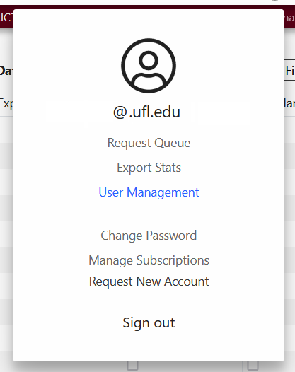
Q2. How do I request access to Signal4 Analytics?
You can request access to Signal4 Analytics by going to the person icon on the right-hand side of the application and selecting request an account or you can request an account through this link.
For more information see this document or watch this short video.
Q3. How do I as a Consultant/Vendor request access to Signal4 Analytics? (If my contract is not with FDOT)
You can request access to Signal4 Analytics as a Consultant/Vendor by going to the person icon on the right-hand side of the application and selecting request an account or you can request an account through this link.
The project manager from the public agency needs to submit the account request for consultants/vendors and to select the “I am a public agency project manager requesting an account for a consultant” option.
Q4. Can you explain the account request process?
You can request access to Signal4 Analytics as a Consultant/Vendor by going to the person icon on the right-hand side of the application and selecting request an account or you can request an account through this link. The “Request an Account” dialogue will assist in determining if you are eligible for an account with Signal4 Analytics.
Each new agency will be reviewed and approved by the Florida Highway Safety and Motor Vehicles (FLHSMV) for creation.
Each existing agency has a designated User Manager(s), that will receive notification (within 24 hours) and will have each new user request for their agency pending in a request queue for their review. The User Manager is responsible for either approving or rejecting (with a small explanation) each request.
Consultant approval is done by the Florida Department of Transportation (FDOT) or FLHSMV depending on the contract. Usually, it can take up to 2-3 business days for FDOT or FLHSMV to review the consultant account request.
Q5. How do I make changes in User Management in the current Signal4 application?
If you are the designated User Manager, you can click the User Management option upon login and perform several functions. As a User Manager, you can approve or reject requests within the user request queue. You can also sort, filter, and export users. You can disable users by unselecting the account active box. See the screenshot below for an example:
For more information on the functionality of user manager activity watch this short video.
Q6. What are the options behind the login?
Several tabs require access outside of the public-facing dashboard. The additional options include event analysis, network screening, crash record search, standard reports, police report search and the FDOT Geolocation (for FDOT only). For more information on the functionality of these options watch this short video.
Q7. How to approve a user request as a user manager in Signal4?
- The request is made for a new user in your agency
- Agency User Manager for the agency gets an email to approve the user
- User Manager logs in to Signal4 and accesses the queue of user requests through Manage Requests
- Select “Process Request”
- Accept user request
Crash Dashboard Questions
- Q1. In the future will the Dashboard include a city filter?
- Q2. How do you get to the tooltip for Emphasis Area definition?
- Q3. Where do I find a copy of the Strategic Highway Safety Plan?
Q1. In the future will the Dashboard include a city filter?
Cities are included in the dashboard’s Geographic Area Filter.
Q2. How do you get to the tooltip for Emphasis Area definition?
The tooltip for the Emphasis Area definition (concise and detailed) can be found on top of the Emphasis Area chart on the Signal Four Dashboard. Select the question mark on the right of the title: Emphasis Area and a pop-up box will be displayed.
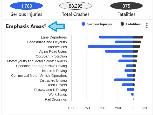

Select “this” from the statement above in the pop-up box and an informational definition sheet will open to include both concise and detailed definitions of the Emphasis Areas.
The Emphasis Area Definitions will then be available as a download (pdf file). This document contains both concise and detailed definitions of the 14 emphasis areas that drive Florida’s traffic safety improvement efforts.

You can also find the document through this link.
Q3. Where do I find a copy of the Strategic Highway Safety Plan?
A copy of the Strategic Highway Safety Plan can be found on the Dashboard page on the right-hand corner by selecting the icon-Target Zero. You can also find the document through this link.
Event Analysis Questions
- Q1. What is the format of the data download and how do you receive the download?
- Q2. Does it include Property Damage Only (PDO)?
- Q3. How can I display top N intersections in Signal4?
- Q4. Where is the total located?
- Q5. Will the maps and graphs be exportable?
- Q6. Where does the 25-foot offset distance measure from (at the intersections)?
- Q7. What do the purple dots mean?
- Q8. Will the ArcGIS exports be updated so that the Data Dictionary fields will include address and zip code data? The prior version of Signal4 Analytics used a variation of the Event export which provided address (though not zip codes), but the new one has very limited fields; pretty much point data by lat/long only.
- Q9. In the result screen, can you move the results part of the screen to the top and not see the map?
- Q10. Does it matter which road is first for the intersection?
- Q11. When will we be able to save queries?
- Q12. When you search crashes by roadway segments, what is the buffer used for the access points, side streets, and driveway connections?
- Q13. What happens if you don’t select specific circumstances?
- Q14. Is the PBCAT crash typing data included and up to date?
- Q15. Can you select a street segment only (not the entire street)?
- Q16. For the intersection selection, black points appear on the map for the intersections. Is it possible to select the points, or do you have to type in the intersecting roadways?
- Q17. How can you determine crashes at the intersection or street level?
- Q18. Where can I find a copy of the Data Dictionary?
- Q19. How do I create a Day of the Week Chart? Or Other charting options?
- Q20. How do I select crash data for a custom area or street network?
- Q21. Can you provide a one-time download of crash report data for a large dataset?
Q1. What is the format of the data download and how do you receive the download?
After you request for a download, a download link will be sent to you via email from the s4-support@ufl.edu email address. The format of the data download can be selected before you download it. See the screenshots below for an example.
Email example you would receive:
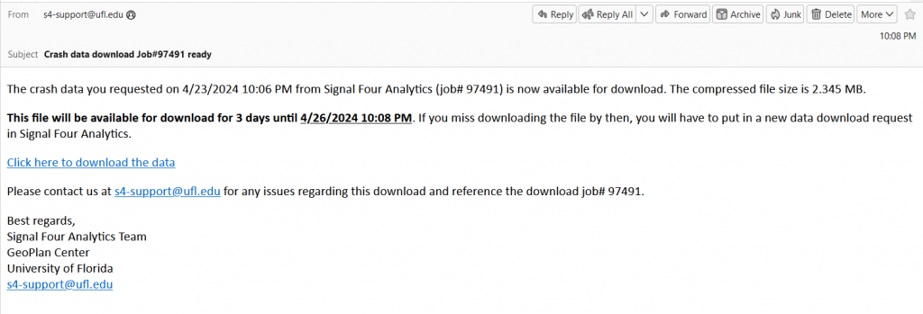
You click on the Click here to download the data link; data will be downloadable via zip file:
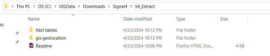
The readme file will explain the download, the data folders, the query parameters, and the files downloaded (to include count). In the zip file, the requested crash tables will be available in csv format, GIS Geolocation data will be available in shapefile format and the crash reports will be available in PDF format.
For more information, watch this short video.
Q2. Does it include Property Damage Only (PDO)?
Data on property damage can be found in the event analysis table. More details on the definition of these data elements can be found in the data dictionary.
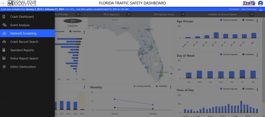
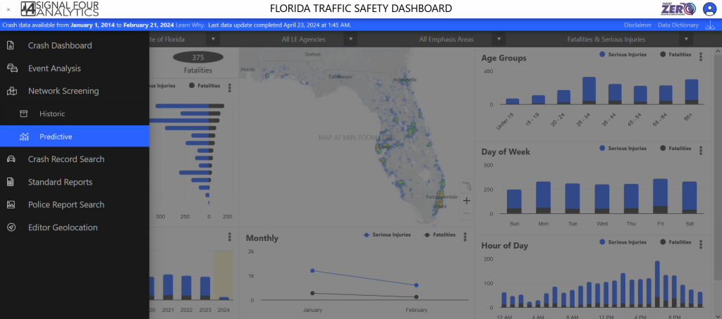
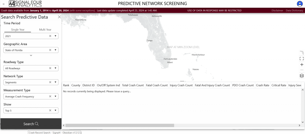
Q3. How can I display top N intersections in Signal4?
Top intersections can be found in the Network Screening predictive feature. You can go to Network Screening, then select predictive. For both single year and multi-year option, you can select the top 5, 10, or 50 crashes in the show option. See the screenshots below for an example:
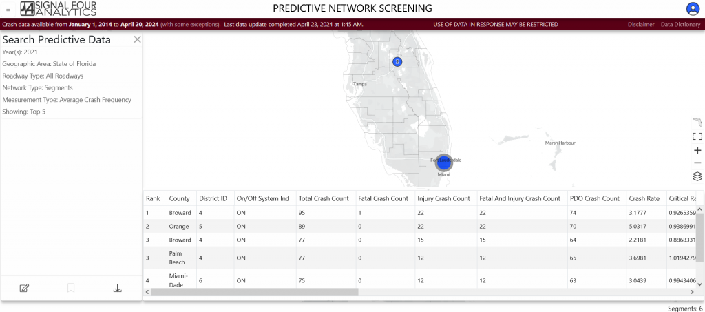
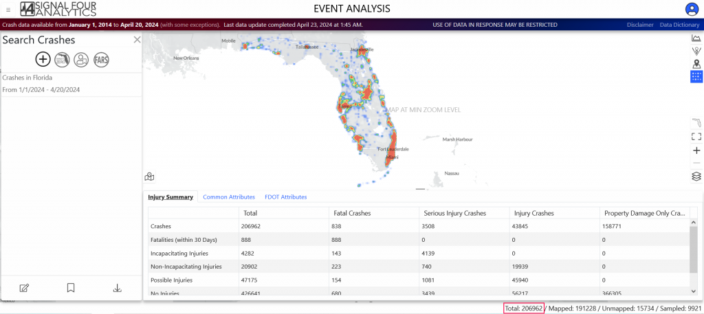
Q4. Where is the total located?
Total number of crashes is located on the bottom right-hand side, under the data grid. See the screenshot below for an example.
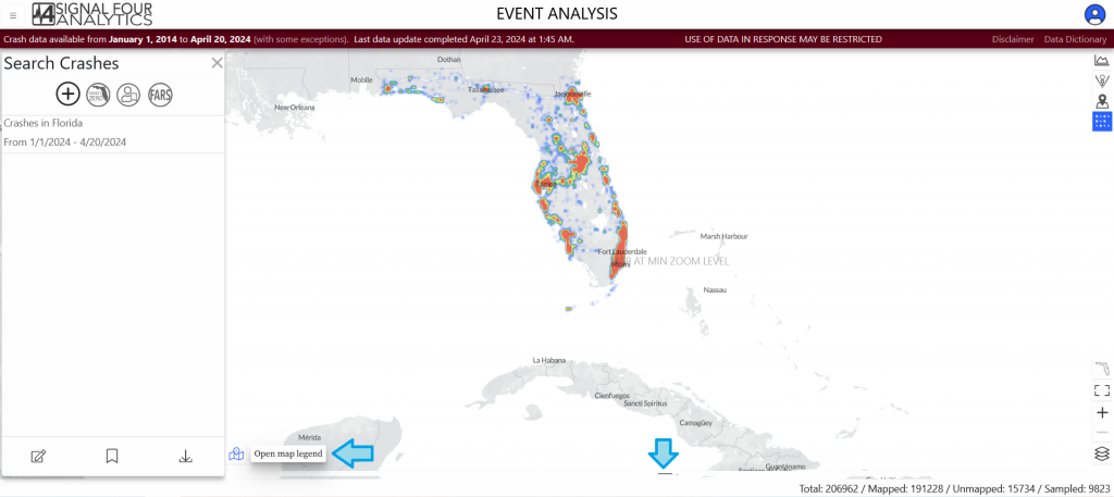
Q5. Will the maps and graphs be exportable?
You can download the charts/graphs in jpeg, png, and pdf format. You can go to the charting option in the top-right corner and select the three-line tab at the top right corner of each chart to see the export options. See the screenshots below for an example.
We still don’t have the export map function available in Signal 4 and don’t have a timeline for it. To export the map, minimize the data grid, chart, open map legend, and take a screen capture of the map. See the screenshots below for an example:
We still don’t have the export map function available in Signal4 and don’t have a timeline for it. To export the map, minimize the data grid, chart, open map legend, and take a screen capture of the map. See the screenshots below for an example.
For more information see this document or watch this short video.
Q6. Where does the 25-foot offset distance measure from (at the intersections)?
The 25-foot offset distance is measured from the center of the intersection.
Q7. What do the purple dots mean?
Multipoint multiple crashes in the same location.
Q8. Will the ArcGIS exports be updated so that the Data Dictionary fields will include address and zip code data? The prior version of Signal4Analytics used a variation of the Event export which provided address (though not zip codes), but the new one has very limited fields; pretty much point data by lat/long only.
Signal4 Analytics has mapped crash data. Zip code information of driver, passenger and non-motorist can be found in different crash tables. You can find more information on these data elements in the data dictionary.
Q9. In the result screen, can you move the results part of the screen to the top and not see the map?
The data grid moves up and down with the arrow button at the top of the data grid. But you can only move the data grid up to the center of the screen, not to the top. You can scroll through the data grid to see the full data and download them. On the other hand, you can move the data grid down and have the map visible on the whole screen. See the screenshots below for an example:
Q10. Does it matter which road is first for the intersection?
No, you can select either roadway.
Q11. When will we be able to save queries?
After requesting a query, the queries can be saved through the bookmark icon in the bottom left of the screen. The saved queries can be found in the existing query option in the top left of the screen.
Q12. When you search crashes by roadway segments, what is the buffer used for the access points, side streets, and driveway connections?
There is no buffer used there but if you want all crashes, it is suggested use the custom network tool instead the search network. In this way, it shows all the crashes including the ones in the cross sections.
Q13. What happens if you don’t select specific circumstances?
If you don’t select specific circumstances the default selection for the Date Range would be a past week and the Geographic location would be the State of Florida.
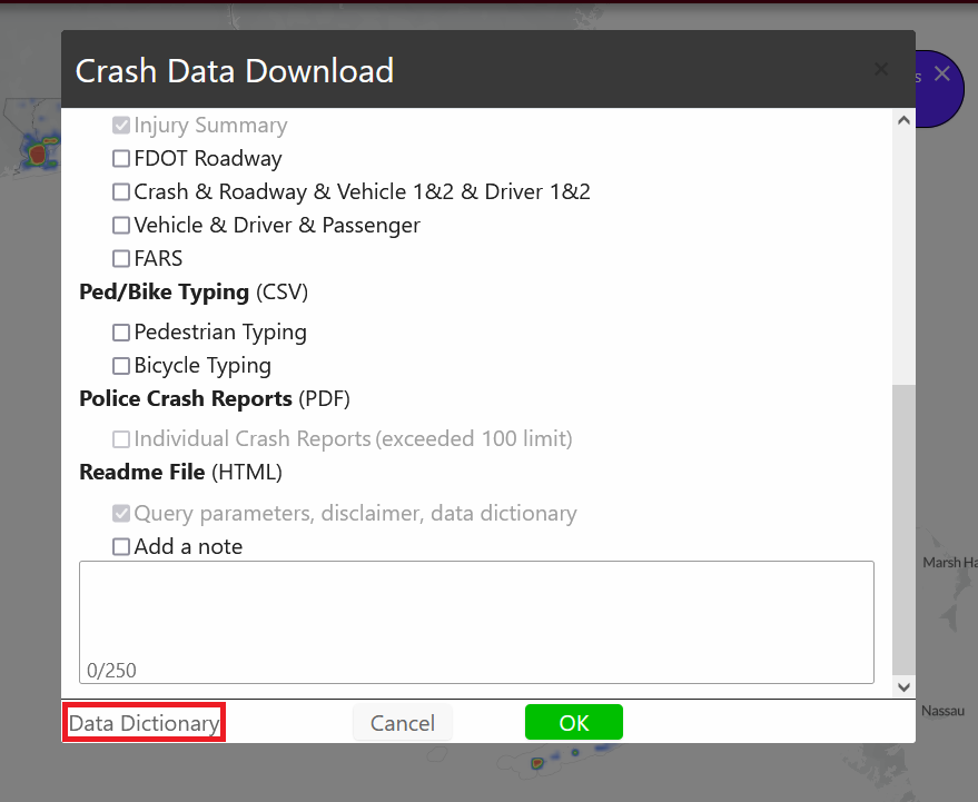
Q14. Is the PBCAT crash typing data included and up to date?
Yes, in the PBCAT the crash typing data is included and up to date for pedestrian and bicycle path crashes. You just need to select the pedestrian typing and bicycle typing option when you go to data download as shown in the following screenshot:
Also, currently, we’re planning to migrate to PBCAT-3 and in the future, all the bike path crashes are expected to have a PBCAT-3 crash type.
Q15. Can you select a street segment only (not the entire street)?
Yes, you can select a street segment through a custom network option in event analysis and network analysis. For more information, watch this video.
Q16. For the intersection selection, black points appear on the map for the intersections. Is it possible to select the points, or do you have to type in the intersecting roadways?
You can use either feature to filter for intersections.
Q17. How can you determine crashes at the intersection or street level?
You can derive crashes for a specific intersection or street level in two ways in event analysis and network screening. Firstly, crashes can be searched for a specific area or intersection through the name of the street/intersection. Secondly, it can be searched through a custom network option by selecting a specific street or intersection manually on the map. For more information see this document or watch this short video.
Q18. Where can I find a copy of the Data Dictionary?
You can open a copy of the Data Dictionary from the blue or red banner at the top right of each Section as shown in the following screenshot (Dashboard, Crash Record Search, Network Screening, Event Analysis, Standard Report, DOT Geolocation).

Or you can find a copy of the Data Dictionary -once, you have chosen the data download option at the lower left corner of the screen:
You can also find the document through this link.
Q19. How do I create a Day of the Week Chart? Or other charting options?
You will need to create a column in excel with the name “Day of Week”: shortcut- =TEXT(C2, “DDD”) as the formula. Please see chart shortcuts.
Q20. How do I select crash data for a custom area or street network?
Users have the option to upload a GIS boundary in the GeoJSON format. To convert features to GeoJSON format, you can use the Feature to JSON (Conversion) tool in ArcGIS Pro.
They can also upload a GIS boundary in the GeoJoin format. There is a tool in ArcGIS to convert from shapefile to this format.
Q21. Can you provide a one-time download of crash report data for a large dataset?
Needs answer
Crash Record Search Questions
- Q1. How do I download crash reports?
- Q2. What is driving the limitation of 100 crashes per download?
- Q3. How do I download a GIS data-mapped crashes?
- Q4. How do I export the data attribute table out of ArcGIS Pro?
- Q5. How do I search for crashes/HSMV report by Agency report number?
Q1. How do I download crash reports?
Downloading a crash report requires a login, once you login to Signal4 Analytics you can go to the tab entitled Record Search. By using either the HSMV Report # or Agency Report # you can download crash reports. You can also use either a .txt file or a .csv. For more information watch this video.
Q2. What is driving the limitation of 100 crashes per download?
This limitation has to do with image sent to us by FLHSMV. This is a temporary issue and we are working to resolve it soon.
Q3. How do I download GIS data-mapped crashes?
In order to download the data in GIS geolocation format, follow these steps:
- Select Your Data: Search the required data
- Initiate the Download: Click the Download button, located at the bottom left area.
- Choose the Download Format: Select GIS Geolocation (ESRI Geodatabase) from the list of available formats.
- Specify the Type of Data: Decide whether you need just the geolocation data or both geolocation and crash event details.
- Check the appropriate box: either Geolocation Only or Geolocation & Crash Event.
For more information see this document or watch this video.
Q4. How do I export the data -attribute table out of ArcGIS Pro?
Please see guide on ArcGIS Pro data export through this link.
Q5. How do I search for crashes/HSMV report by Agency report number?
In the Search Records panel, click on the Agency tab. Select the law enforcement agency you are searching by the report number of in the LE Agency dropdown. Then enter the agency report number(s) and select Search.